Caddie Budget Digital Terrain Modelling
Who will benefit from Caddie Budget DTM?
Anyone involved in Civil Engineering, Surveying or the Construction Industry dealing with real world sites where levels can be anything but flat.
Why Caddie Budget DTM?
Previously, for those preparing site models, sections and contour drawings, Caddie Professional's Digital Terrain Modelling Application (DTM) provided the only really cost effective .DWG solution.
Now with the addition of Caddie Budget DTM to the Caddie stable, those same advanced terrain modelling tools have become available to those wanting only to augment their existing CAD capabilities rather than replace them, or needing less overall CAD functionality than is provided by the full Caddie Professional package.
Caddie Budget DTM provides all the main application CAD tools of the Caddie Budget package to provide a comprehensive basic drafting solution, but with the addition of the specialist terrain modelling tools that help transform productivity levels way beyond that normally expected at this price point.
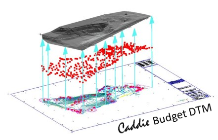
The site models and sections produced using Caddie Budget DTM (and Caddie DTM) when saved, will be in the industry standard .DWG drawing format, making them perfect for working on, not only in Caddie, but also in any other .DWG compatible system.
What information can you produce using Caddie Budget DTM
Whether using data from Total Stations, Promap or your own site levels, with Caddie Budget DTM you can save hours of dull, repetitive work, reducing the risk of error and creating 3D site models in seconds, and multiple sections in under a minute. With Caddie Budget DTM you can view your sites from any angle to get a better appreciation of the opportunities and challenges they offer, even draping images such as aerial photographs to view site features. And using Caddie Budget DTM requires no special training, so you can be modelling and sectioning your sites in minutes.
Andrew Newman of LK2 Architects tells how he saved himself 2 days work by using Caddie DTM
‘Caddie’s DTM tools are amazingly quick to use; in an hour I produced a 3D model of the terrain and 4 sections through my site, all from a 2D plan.
It would have taken me at least 2 days to produce the same information the way I used to, using AutoCAD and Sketchup.’
Caddie Budget DTM - Terrain modelling made simple
Caddie Budget DTM provides you with:
Direct input of Total Station drawings from site surveyors and mapping providers
Caddie loads and saves in .DWG, also supporting .DXF to make it easy to create your site models and sections from surveyors drawings, Ordnance Survey data and from providers such as Promap
Automatic generation of 3D point heights from 2D survey drawings
Produce a 3D model of your site from a 2D survey drawing in seconds, saving time and reducing transcription errors
Automatic 3D TIN (Triangular Irregular Network) generation from 3D points
Produce a 3D TIN model of your site from 3D point height data as supplied by Promap with their DSM (surface) and DTM (terrain) mapping data
Site Levelling with volume change information
Revise your site model including any changes in level and get an instant readout of the volume difference to save time and reducing the need for manual calculation
Optimised cut and fill
Automatic calculation of optimum level for cut and fill schemes including soil type shrinkage factor to help reduce transport of material to and from site and minimize environmental impact
Automatic generation of site sections
Create site sections in seconds, complete with section markers, reference heights and datum levels, saving hours of plotting points, transcribing information and reducing errors
Automatic regeneration of site sections
Automatically update the site sections to see the effects any level revisions have on your proposals to facilitate more effective site evaluation
Volume difference calculation
Automatic calculation of the volume difference between TIN models to help in the planning and costing of site re-modelling
Automatic generation of site contours
Create site contour drawings in seconds, complete with major and minor contours and height labels to provide a 2D representation of 3D site make-up
Conversion of 3D TIN models to 3D Meshes
Automatic generation of a 'softened' 3D Mesh from a 3D TIN model to provide a more natural and smoothed site appearance
Image drape
Map aerial photographs and other images onto your site models to bring the features of your site model 'to life'
All trade marks acknowledged
User comments are their own and ACS is not responsible for these or matters arising