Caddie Digital Terrain Modelling Application
The Digital Terrain Modelling Application that is standard in Caddie is a very powerful tool for anyone involved in Civil Engineering, Surveying or the Construction Industry dealing with real world sites where levels can be anything but flat, Caddie's Digital Terrain Modelling Application (DTM) provides the perfect tool for preparing the site models, sections and contours needed to fully develop a scheme.
Whether using data from Total Stations, Promap or your own site levels, with Caddie Digital Terrain Modelling Application (DTM) you can save hours of dull, repetitive work, reducing the risk of error and creating 3D site models in seconds, and multiple sections in under a minute.
With Caddie DTM you can view your sites from any angle to get a better appreciation of the opportunities and challenges they offer, even draping images such as aerial photographs to view site features. And using Caddie DTM requires no special training, so you can be modelling and sectioning your sites in minutes.
Caddie uses the industry standard DWG drawing format, also supporting DXF, making it easy to create models and sections using information from surveyors, Ordnance Survey mapping sites, as well as your own survey data.
The Caddie Digital Terrain Modelling Application Provides You With:
Direct input of Total Station drawings from site surveyors and mapping providers
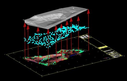
Caddie loads and saves in DWG, also supporting DXF to make it easy to create your site models and sections from surveyors drawings, Ordnance Survey data from providers such as Promap.
Direct import and plotting of data from spreadsheets and text files
Save time and reduce errors by loading and plotting survey data including coordinates and feature descriptions direct from their original files without the need to transcribe.
Download GPS data with automatic conversion from WGS84 to local grid
Load information direct from GPS units with automatic conversion and plotting to save time and reduce transcription errors.
Automatic generation of 3D point heights from 2D survey drawings
Produce a 3D model of your site from a 2D survey drawing in seconds, saving time and reducing transcription errors.
Automatic 3D TIN (Triangular Irregular Network) generation from 3D points
Produce a 3D TIN model of your site from 3D point height data as supplied by Promap with their DSM (surface) and DTM (terrain) mapping data.
Site Levelling with volume change information
Revise your site model including any changes in level and get an instant readout of the volume difference to save time and reducing the need for manual calculation.
Optimised cut and fill
Automatic calculation of optimum level for cut and fill schemes including soil type shrinkage factor to help reduce transport of material to and from site and minimize environmental impact.
Automatic generation of site sections
Create site sections in seconds, complete with section markers, reference heights and datum levels, saving hours of plotting points, transcribing information and reducing errors.
Automatic regeneration of site sections
Automatically update the site sections to see the effects any level revisions have on your proposals to facilitate more effective site evaluation.
Volume difference calculation
Automatic calculation of the volume difference between TIN models to help in the planning and costing of site re-modelling.
Automatic generation of site contours
Create site contour drawings in seconds, complete with major and minor contours and height labels to provide a 2D representation of 3D site make-up.
Conversion of 3D TIN models to 3D Meshes
Automatic generation of a 'softened' 3D Mesh from a 3D TIN model to provide a more natural and smoothed site appearance.
Direct download of image tiles from aerial mapping sites
Download aerial mapping images and use them to enhance the contextual appreciation of your schemes by placing them in their environment.
Image drape
Map aerial photographs and other images onto your site models to bring the features of your site model 'to life'.
The Caddie Digital Terrain Modelling Application is included as standard with Caddie Professional
'Caddie’s DTM tools are amazingly quick to use; in an hour I produced a 3D model of the terrain and four sections through my site, all from a 2D plan.
It would have taken me at least two days to produce the same information the way I used to, using AutoCAD and Sketchup.'